SWIM: About Pages


Curious about what SWIM is all about? Please explore the short articles, written by SWIM Team Members covering various aspects of the datasets included in the search for subsurface water ice on Mars.

Follow us on Twitter!

Geomorphic Mapping

By: Drs. David Hollibaugh Baker and Gareth Morgan
Last Updated: 11/05/2020

Geomorphic mapping is a powerful tool to infer the presence of subsurface ice through the identification and analysis of assemblages of landforms that have been formed by and/or modified through ice-related processes. Our team is mapping the spatial distribution of glacial and periglacial landforms to help determine if ice existed or currently exists in the Martian subsurface. We are using a grid-mapping approach (Ramsdale et al., 2017) to efficiently survey these landforms across Mars between 60͒°S-60°N. We primarily use data obtained from the Mars Reconnaissance Orbiter (MRO) Context Camera (CTX) (Malin et al., 2007) and High Resolution Imaging Science Experiment (HiRISE) (McEwen et al., 2007) and derived products, including a global CTX image mosaic (Dickson et al., 2018).

Certain types of thermal contraction crack polygons are formed due to the presence of ice in the upper meters of the surface (Levy et al. 2010) and their presence is therefore being used to infer the spatial distribution of shallow ice at present or in the very recent past. Other small-scale terrains and landforms, such as sublimation-type pits and patterns (Milliken et al., 2003), are also being used to infer the presence of shallow ice.

Figure 1: Boundary between smooth and dissected mantle. As can be seen in this image of the surface of Mars at 54 °N, a smooth mantling material covers most of the preexisting terrain. Throughout the scene, the mantling cover has been stripped away, revealing (in some areas) a pitted texture suggestive of the removal of ice via sublimation. CTX image: J04_046213_1264_XN_56N151W.

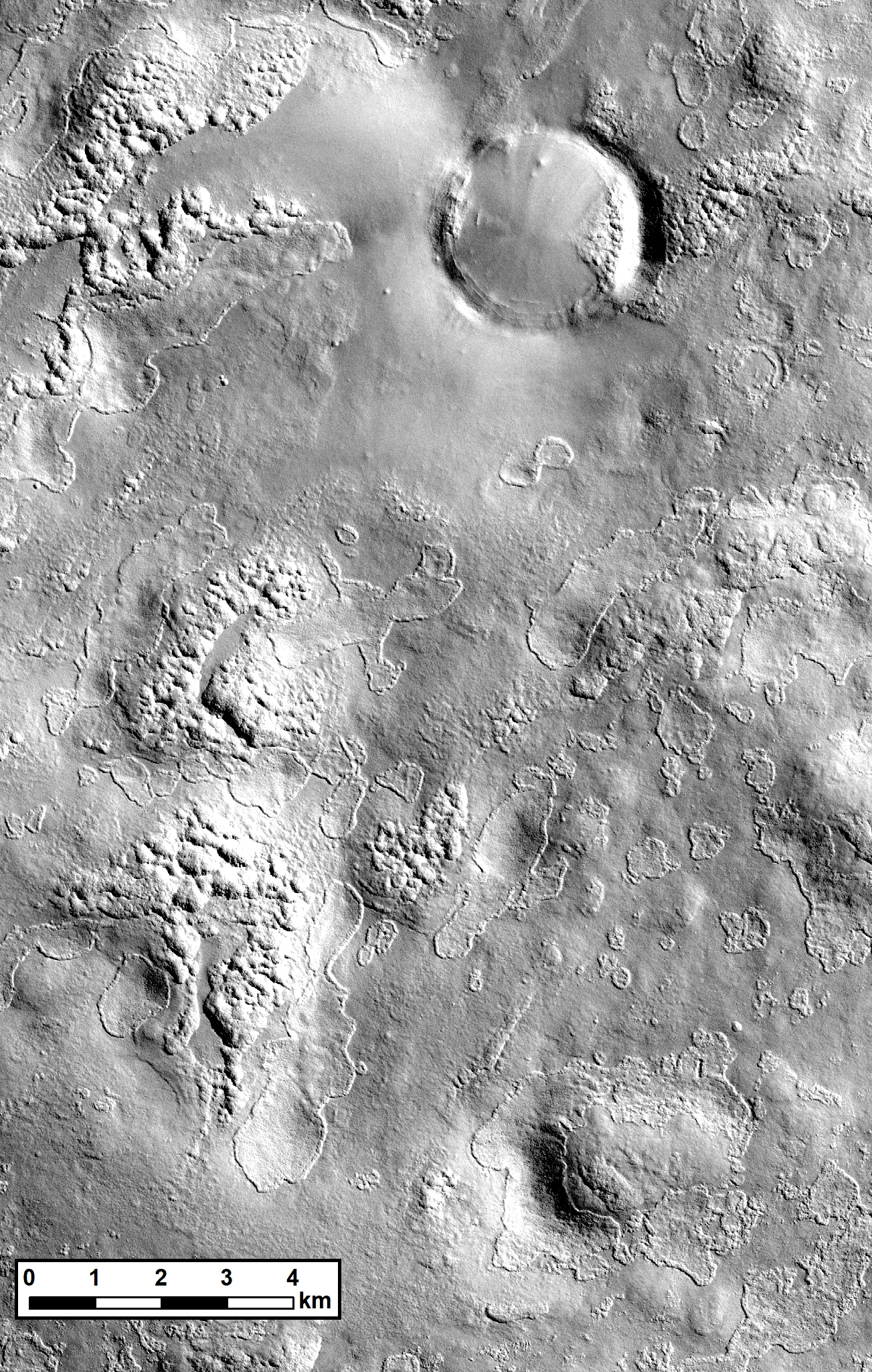
Even deeper ice deposits are evidenced by large pits, cliffs and scalloped terrain carved into draping, dusty “mantle” deposits that are tens of meters in thickness (Morgenstern et al., 2007; Baker and Head, 2015; Dundas et al., 2018). While many of these landforms may be relicts of the past modification of ice-rich materials, it is likely that ice is still currently present at these locations. Impact craters are also natural probes that excavate and are modified by subsurface ice. Impact craters formed within the last decade expose shallow ice (Dundas et al., 2014), and older craters exhibit expanded rims (Viola et al., 2015), terraces (Bramson et al. 2015), and other interior structures (e.g., Baker and Carter, 2019b) that result from the presence of ice at the time of impact and the post-impact deposition of ice-rich materials.

The presence of glacial features are also being used to infer the distribution of even larger reservoirs of ice. Massive lobate debris aprons (LDA), lineated valley fill (LVF), and concentric crater fill (CCF) extend for tens of kilometers, have integrated flow-like patterns, and are hundreds of meters in thickness (e.g., Morgan et al., 2009; Baker et al., 2010; Head et al., 2010). Recent work combining geomorphology with SHARAD radar sounding data show that most of these features contain nearly pure ice throughout their thickness (Petersen et al., 2018) and have volumes comparable in scale to all the alpine glaciers on Earth (Levy et al., 2014). Younger and smaller glacial landforms, including viscous flow features (Milliken et al., 2003) and glacier-like forms (Sounness et al., 2012), contain ice in smaller amounts and restricted locations.

Figure 2: Two scales of ice-related morphology. Pits with distinctive scalloped margins cross the scene (centered at 45 °N) which have been argued to have formed from the sublimation of ice. Overprinted on top of the pits are Polygons, 10s of meters across. On Earth, polygons and other types of patterned ground are indicative of shallow ice. As the polygons have formed on top of the pits, it suggests they indicate the presence of recently deposited, shallow ice. HiRISE image: ESP_019950_2250

References and Additional Reading

Baker, D.M.H., Carter, L.M., 2019a. Probing supraglacial debris on Mars 1: Sources, thickness, and stratigraphy. Icarus 319, 745–769. doi:10.1016/j.icarus.2018.09.001Baker, D.M.H., Carter, L.M., 2019b. Probing supraglacial debris on Mars 2: Crater morphology. Icarus 319, 264–280. doi:10.1016/j.icarus.2018.09.009Baker, D.M.H., Head, J.W., 2015. Constraints on the depths of origin of peak rings on the Moon from Moon Mineralogy Mapper data. Icarus 258, 164–180. doi:10.1016/j.icarus.2015.06.013Baker, D.M.H., Head, J.W., Marchant, D.R., 2010. Flow patterns of lobate debris aprons and lineated valley fill north of Ismeniae Fossae, Mars: Evidence for extensive mid-latitude glaciation in the Late Amazonian. Icarus 207, 186–209. https://doi.org/10.1016/j.icarus.2009.11.017Bramson, A.M., Byrne, S., Putzig, N.E., Sutton, S., Plaut, J.J., Brothers, T.C., Holt, J.W., 2015. Widespread excess ice in Arcadia Planitia, Mars. Geophys. Res. Lett. 42, 2015GL064844. doi:10.1002/2015GL064844Dickson, J.L., Kerber, L.A., Fassett, C.I., Ehlmann, B.L., 2018. A global, blended CTX mosaic of Mars with vectorized seam mapping: A new mosaicking pipeline using principles of non-destructive image editing. Lunar Planet. Sci. Conf. 49, no. 2480.Dundas, C.M., Byrne, S., McEwen, A.S., Mellon, M.T., Kennedy, M.R., Daubar, I.J., Saper, L., 2014. HiRISE observations of new impact craters exposing Martian ground ice. J. Geophys. Res. Planets 119, 2013JE004482. doi:10.1002/2013JE004482Dundas, C.M., Bramson, A.M., Ojha, L., Wray, J.J., Mellon, M.T., Byrne, S., McEwen, A.S., Putzig, N.E., Viola, D., Sutton, S., Clark, E., Holt, J.W., 2018. Exposed subsurface ice sheets in the Martian mid-latitudes. Science 359, 199–201. doi:10.1126/science.aao1619Head, J.W., Marchant, D.R., Dickson, J.L., Kress, A.M., Baker, D.M., 2010. Northern mid-latitude glaciation in the Late Amazonian period of Mars: Criteria for the recognition of debris-covered glacier and valley glacier landsystem deposits. Earth and Planetary Science Letters, 294, 306–320. doi:10.1016/j.epsl.2009.06.041Levy, J.S., Marchant, D.R., Head, J.W., 2010. Thermal contraction crack polygons on Mars: A synthesis from HiRISE, Phoenix, and terrestrial analog studies. Icarus, Solar Wind Interactions with Mars 206, 229–252. https://doi.org/10.1016/j.icarus.2009.09.005Levy, J.S., Fassett, C.I., Head, J.W., Schwartz, C., Watters, J.L., 2014. Sequestered glacial ice contribution to the global Martian water budget: Geometric constraints on the volume of remnant, midlatitude debris-covered glaciers. J. Geophys. Res. Planets 119, 2014JE004685. https://doi.org/10.1002/2014JE004685Malin, M.C., Bell, J.F., Cantor, B.A., Caplinger, M.A., Calvin, W.M., Clancy, R.T., Edgett, K.S., Edwards, L., Haberle, R.M., James, P.B., Lee, S.W., Ravine, M.A., Thomas, P.C., Wolff, M.J., 2007. Context Camera Investigation on board the Mars Reconnaissance Orbiter. J. Geophys. Res. 112, E05S04.McEwen, A.S., Eliason, E.M., Bergstrom, J.W., Bridges, N.T., Hansen, C.J., Delamere, W.A., Grant, J.A., Gulick, V.C., Herkenhoff, K.E., Keszthelyi, L., Kirk, R.L., Mellon, M.T., Squyres, S.W., Thomas, N., Weitz, C.M., 2007. Mars Reconnaissance Orbiter’s High Resolution Imaging Science Experiment (HiRISE). J. Geophys. Res. 112, E05S02.Milliken, R.E., Mustard, J.F., Goldsby, D.L., 2003. Viscous flow features on the surface of Mars: Observations from high-resolution Mars Orbiter Camera (MOC) images. J. Geophys. Res. 108, 5057. doi:10.1029/2002JE002005Morgan, G.A., Head III, J.W., Marchant, D.R., 2009. Lineated valley fill (LVF) and lobate debris aprons (LDA) in the Deuteronilus Mensae northern dichotomy boundary region, Mars: Constraints on the extent, age and episodicity of Amazonian glacial events. Icarus 202, 22–38. doi:10.1016/j.icarus.2009.02.017Morgenstern, A., Hauber, E., Reiss, D., Gasselt, S. van, Grosse, G., Schirrmeister, L., 2007. Deposition and degradation of a volatile-rich layer in Utopia Planitia and implications for climate history on Mars. Journal of Geophysical Research: Planets 112. doi:10.1029/2006JE002869Petersen, E. I., Holt, J. W., Levy, J. S., 2018. High ice purity of Martian lobate debris aprons at the regional scale: Evidence from an orbital radar sounding survey in Deuteronilus and Protonilus Mensae. Geophysical Research Letters, 45, 11,595-11,604.Ramsdale, J.D., Balme, M.R., Conway, S.J., Gallagher, C., van Gasselt, S.A., Hauber, E., Orgel, C., Séjourné, A., Skinner, J.A., Costard, F., Johnsson, A., Losiak, A., Reiss, D., Swirad, Z.M., Kereszturi, A., Smith, I.B., Platz, T., 2017. Grid-based mapping: A method for rapidly determining the spatial distributions of small features over very large areas. Planetary and Space Science 140, 49–61. Souness, C., Hubbard, B., Milliken, R.E., Quincey, D., 2012. An inventory and population-scale analysis of Martian glacier-like forms. Icarus 217, 243–255. doi:10.1016/j.icarus.2011.10.020Viola, D., McEwen, A.S., Dundas, C.M., Byrne, S., 2015. Expanded secondary craters in the Arcadia Planitia region, Mars: Evidence for tens of Myr-old shallow subsurface ice. Icarus 248, 190–204. https://doi.org/10.1016/j.icarus.2014.10.032
Jump to Top